|
|
Order by Related
- New Release
- Rate
Results in Title For 3d map view
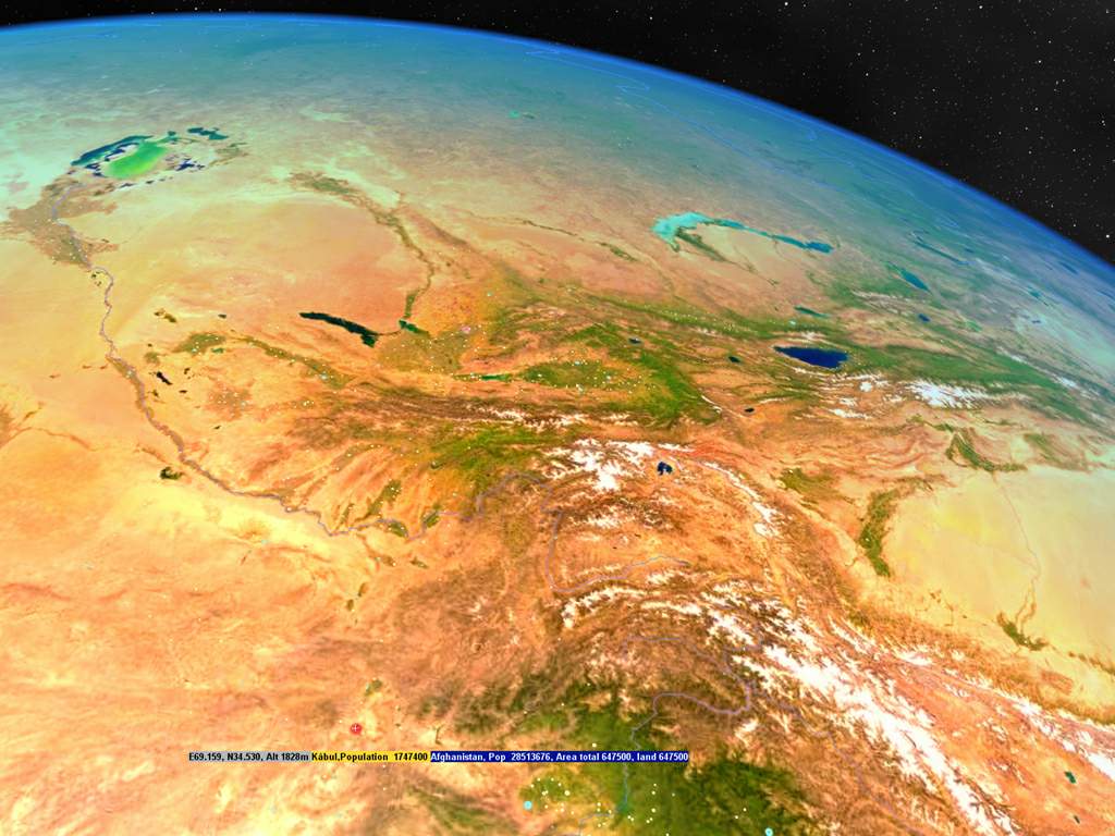 | With 3D World Map you can view the earth in 3D,and get reference on 269 countries and entities,locate and compare 30000 cities in the world,compute distance between any two points on the earth,and more.
The earth model is real 3D,you can amplify the altitude above sea level to see how the earth looks like.also you can run the program as screensaver,with the amazing earth displayed on the screen.
There is an mp3 player for listening to music during you browse the world,it will pick a number of songs randomly from several directories or from all files according your settings every time the program starts.
Almost everything is costomizable in this program,you can change the color of the earth,the color of any button or any windows and the text,if the text is too small or big,just zoom in/out by left and right drag together. .. |
|
 | DXF VCL tools for Borland Delphi and C++Builder developers. TGraphic descendants for every format. TGraphic viewer provided. DCU or Delphi source code. The world's fastest DXF reader. High quality: hatches, splines, viewports.Royalty free licensing. ..
|
|
 | Awakening Mind 1 is a technical manual for creating light and sound sessions on mind machines that will produce desirable altered states of consciousness. .. |
|
 | 3D Photo Browser for 3D Users is a must for viewing, editing and organizing your images, videos, 3D files and audio files. It displays high quality thumbnails in a comfortable customizable window. You see your whole objects library thanks to the multi-folders view. It recognizes more than 60 image formats, many 3D formats and audio files.
You can describe each file using the keywords and information panel then export/import to/from a database or make advanced search based on this information.
The image viewer includes a wide range of tools, slides show, conversion and printing features.
The OpenGL viewer clearly shows scene hierarchy and materials, displays textures and includes slides show, conversion and printing features. It also includes a decimation tool to optimize your scenes.
You can play audio files and edit MP3 information (author, title, track...).
Nothing is more simple that printing a contact sheet of a directory content. You control accurately page setup (fonts, colors...) and can add information under each image using tags feature. Once your settings done, you can save them in the template library.
Batch command feature allows applying a set of commands to a set of files. For example, you can - in a single step - resize, rotate, then convert to 128 colors a set of images. Create your own batch command, save it, or load one of the samples from the batch command library.
Export your images or your 3D scenes to the web using the HTML format. Select the HTML template that fits your needs and let 3D Photo Browser for 3D Users do the job for you.
3D Photo Browser for 3D Users offers a wide range of advanced features, which list increases day by day, thanks to the regularly updates. For example, you can manage albums, send images by email (including resizing and conversion feature), capture still images or movie from screen, rename a set of files, manage your favorites directories, search for files, create AVI or animated GIF from a set of images... ..
|
|
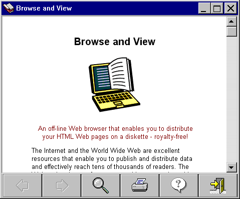 | Browse and View makes the World Wide Web and your HTML pages available to those who do not have Internet access. With Browse and View you can place your HTML pages on a diskette or CD, and distribute your Web site to others! .. |
|
 | ExplorerView is an add on feature to Microsoft Windows Explorer that allows the full instant preview of files from within Windows Explorer. Using ExplorerView there is no longer any need to open a file with its application to display its contents. With ExplorerView you can find the right file the first time, every time, and fast!
Copy and paste text and graphics from the Explorer Window right into a new document!
Full instant preview of documents, picutres, movies, music and graphics.
No need to have the creating application installed.
Rotate graphics and print right from within Windows Explorer. ..
|
|
 | Image View was designed to provide a slide show of single or side-by-side digital images. Text may also accompany an image as shown in the demo version. The images are shown following a script designed by the user and can also incorporate video and audio clips as well, providing a rich multimedia experience.
The Image View Suite includes the script writer, a text writer used for incorporating text into the slide show, an image library cataloger, the data creator which allows titling of the images, a scan optimizer used in congunction with your scanner to create scans which optimizes their display size, and a utility which allows the downloading and titling of images from the web. .. |
|
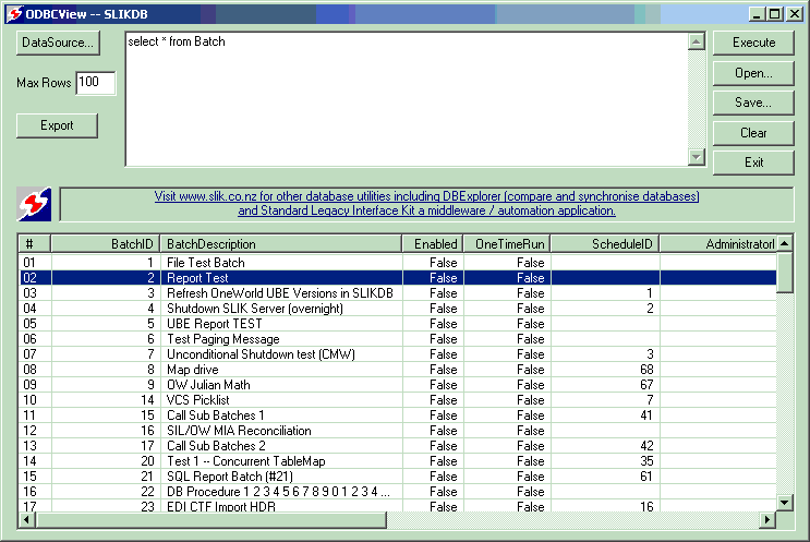 | ODBCView is a free SQL query tool to view and export data from any OBDC database. Data is displayed on a read-only grid and can be exported to a CSV or HTML report. Note, any valid SQL statements can be executed including SQL UPDATE and DELETE stmts. .. |
|
 | Autorun software that is quick and easy to learn. The auto creation wizard will guide you through developing a project. Featuring an intuitive, visual development environment requiring no programming language or training class to get the job done. .. |
|
 | Able Page View is a fax and tiff viewer and converter, offers you a full solution for viewing, printing, saving, converting.
Able Page View can show all kinds of FAX images, multipage FAX and TIFF images (rev.6.0, Packbits, LZW, CCITT G.3 and G.4) with RGB, CMYK, B/W, animated GIF.
Also FAX (CCITT3), G3F and G3N (Zetafax) formats supported for loading.
Able Page View supports many FAX file formats. Supported 4, 8, 16, 32, 64, 128 and 256 colors paletted images.
Images viewed on the screen can be sent directly to any printer supported by your operating system.
Size, area and position are adjusted using a comfortable printer dialog.
Able Page View can convert FAX and TIFF files to standard TIFF/FAX format, JPEG format (RGB, GrayScale, YCbCr, CMYK, YCbCrK),
PNG, BMP, PCX, GIF, DIB, RLE, TGA (TARGA, VDA, ICB, VST, PIX), Portable Bitmap PBM, PDF, PS.
Able Page View software is a small, fast and efficient viewer and converter for Windows.
You can send the fax by printing to "FAX printer" (Windows NT Fax Driver).
Supported the input image file formats: FAX, TIFF, GIF.
Supported the output image file formats: FAX, TIFF, GIF, JPEG, PNG, BMP, PCX, DIB, RLE, TGA, PBM, PGM and PPM.
Supported TIFF compressions: rev.6.0, Packbits, LZW, CCITT G.3 and G.4.
Supported color depths: 1 Bit (black/white), 4 Bit (16 colors/graylevels), 8 Bit (256 colors/graylevels) and 24 Bit (16,7 mio. colors), transparency.
View functions: Scrolling (using cursor control keys, scrollbars), zooming (+/- keys, menufunctions or drawing a rectangular area), antialiasing, rotation (90 and 180 .. |
|
Results in Keywords For 3d map view
 | Usually, the specific file need to specify program opens.For example, DOC opens with WORD, XLS opens with EXCEL.These general software in our computer have installation.But if we meet the file that not known,are you go to the Internet to seek and download it's corresponding program?Now, have got Magic View&Converter, you need not worry.
Since Magic View&Converter does not care for file is founded by what kind of software,it is to distinguish according to the content of file instead of the extension name of file only.Therefore no matter scanner, the software of file processing, the software of CAD graph and electronic form, and the file founded by other softwares , it can open and show normally fast. It Display over 400 different file formats without the authoring application. Magic View&Converter can support Word, Excel, PowerPoint, Visio, Lotus123 and TIFF etc various popular official business and graph file format.The support for 2D CAD is fairly outstanding too.Can directly open DWG, DXF, DWF, MicroStation, DGN, HPGL, CGM, IGES, ME10, Cadkey, EPS and Visio file.For designer , the possibility of more contact is the file of 3D CAD.If install professional mechanical design or electronic design software only for view or print a file, its price will not be too little perhaps. Magic View&Converter has offered good support for 3D CAD,for example CATIA, UG, Pro/E, Soild, Edge, SolidWorks, Inventor, Mechanical, JT, ACIS, STEP, IGES, STL and VRML etc.
We can use Magic View&Converter convert the file of all supports to PDF,CALS GP4,FAX,HPGL,TIFF,BMP etc.At the same time,It is one very excellent print control software,Offer print option include postmark, watermark and banner... |
|
Results in Description For 3d map view
| With 3D World Map you can view the earth in 3D,and get reference on 269 countries and entities,locate and compare 30000 cities in the world,compute distance between any two points on the earth,and more.
The earth model is real 3D,you can amplify the altitude above sea level to see how the earth looks like.also you can run the program as screensaver,with the amazing earth displayed on the screen.
There is an mp3 player for listening to music during you browse the world,it will pick a number of songs randomly from several directories or from all files according your settings every time the program starts.
Almost everything is costomizable in this program,you can change the color of the earth,the color of any button or any windows and the text,if the text is too small or big,just zoom in/out by left and right drag together... |
|
| STT VIEW is a browser for vector maps. It is part of the STT Suite (Simple Tracing Tool). The binary vector format used by STT SURV is supported as well as the conventional Polish format which is ASCII-based and will be automatically converted into a binary vector map by the program. STT VIEW is easy to use. You may also connect to a GPS receiver, retrieve its position and display it on the vector map in real-time...
|
|
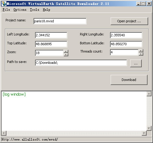 | Microsoft VirtualEarth Satellite Downloader is a cute tool that help you to get small tile satellite images from Microsoft VirtualEarth. All downloaded small images are saved on the disk. You can view downloaded maps by Map Viewer Or you can combine them into a big BMP map. It supports proxy server. Isn't it very cool that you make your city's high precision satellite map by yourself?!.. |
|
| Need For Extreme 3D - a new 3D race game with 3D person view from above that is original for this genre. The game purpose is to be the first...
|
|
 | View maps of Earth and other planets with PrettyMap! See current day and night areas, learn geography with the quiz, enjoy 3D elevation surfaces, measure distances between locations and create your own maps with special places! PrettyMap lets you view vector and raster maps and images (such as country boundaries, world cities, rivers, satellite photos), search in geographically-referenced data, visualize and analyze spatial information, extend your knowledge, and edit your own simple maps. PrettyMap is a GIS program with the following features:
- support for vector maps (points, lines, areas)
- support for raster maps (terrain elevation and bathymetry, images, symbolic)
- handles multi-attribute data associated with vector map objects
- displays maps of various planets
- free maps available:
* country boundaries with country names, capitals, population sizes, ...
* major cities with names, status, population ranks and classes, ...
* USA states with areas, population sizes, males, females, age, marriage, race, and household statistics, ...
* major rivers
* elevation data for Earth, Moon, Mars
* and many more!
- internet connection not required on your PDA
- various color schemes for elevation maps
- user-defined elevation colors
- zoom range from whole planet to meters
- shows day and night area, computes shadow length and sun/north orientation
- multiple, configurable vector map layers
- data search for vector map databases
- versatile quiz with teacher mode for vector map databases
- bar charts and color-by option for numeric features in vector map databases
- relief and 3D elevation (DEM) view with vector map overlay
- distance measurement
- integrated user-defined locations (Points Of Interest) editor, stores notes and values for each POI
- sessions to quickly save/restore program state
- adjustable water level for elevation data
- numerous settings to customize the program.. |
|
| EarthNavigator is a powerful PalmOS application that displays an interactive map in your palm. You can also view the full earth map, coordinates, distances between points, population, the local time, day&night, track expenses and much more. It's fun, it's educational and for businesses! Unique navigation system for Palm OS devices!..
|
|
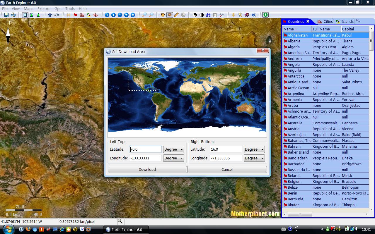
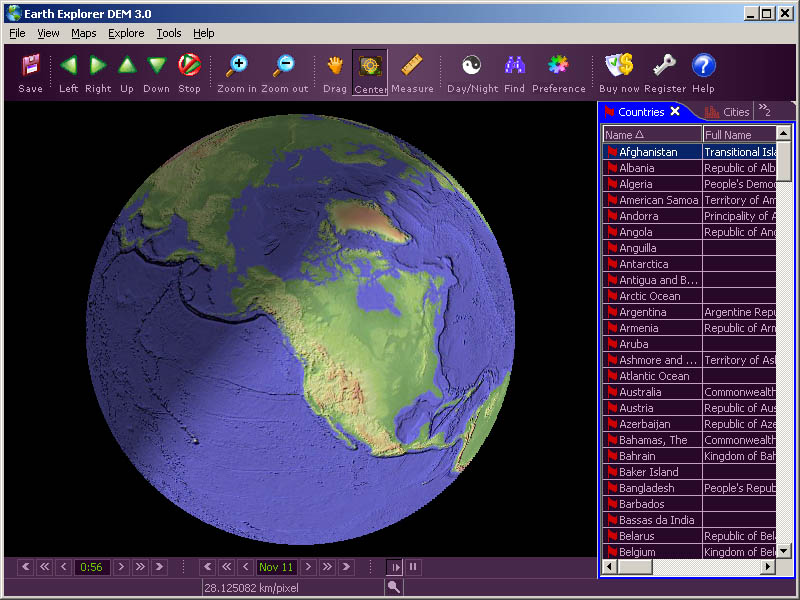 | Earth Explorer DEM integrates high-resolution shaded relief topographic imagery (built from 1km resolution digital elevation model) with kinds of map layers such as political boundaries, coastlines, rivers, lake and island boundaries, 267 countries and regions, 40000+ ranked cities, 15000+ islands, and 1700+ noteworthy historical earthquakes since 1980 into a fantastic 3D earth globe. You can specify what kinds of map layers to be shown, rotate the globe, click right mouse button and pull/push to zoom in/out the current map view, measure distance between any two points on the map, etc.
Key features:
1. A 3D bird's-eye view of our beautiful earth;
2. Photo-realistic shaded relief topographic imagery at 1km resolution covered entire earth globe;
3. Integrates with several kinds of map layers:
Vector map layers:
1) Political boundaries (International boundaries and internal boundaries);
2) Coastlines, lakes, islands and rivers;
3) Longitude-latitude grids;
Point map layers:
1) 267 countries/regions and detailed information;
2) 40000+ ranked cities and information;
3) 15000+ Islands and information;
4) 1700+ noteworthy historical earthquakes since 1980 and detailed information;
4. Rotate/Zoom in/Zoom out functions lets you observe our beautiful planet at any point (Click right mouse button and pull/push to zoom in/out the current map);
5. Three kinds of operation modes (Drag, Center, Measure);
6. Measure distance between any two points on the globe;
7. Intelligent tips when your mouse moves upon a country/city/island/earthquake's mark or name label;
8. Sort country/city/island/earthquake table according to selected titles and interactive operate with the label and mark on the map;
9. Save favorite maps with BMP, JPEG formats;
With the newly redesigned interface and configuration utilities with the highest level of features and quality, Earth Explorer DEM 2.5 works well under the Windows 98/ME/NT/2000/XP systems... |
|
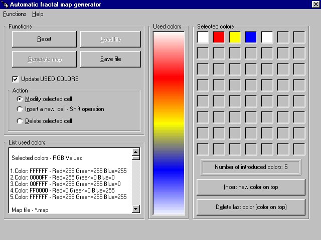 | The program generates and manages .map files. Fractal programs such as Winfract and Fractint make use of .map files which contain 256 lines of ASCII characters which describe RGB (red,green,blue) color values. While such .map files can be generated with any text editor, doing so can be very tedious. This program provides a much quicker and more convenient means of generating and/or modifying .map files, utilizing a GUI interface. .. |
|
 | Do you want to play free game racing? Need For Extreme 3D a new 3D race game with 3D person view from above that is original for this genre. The game purpose is to be the first. There are two game modes Tournament and Single Race... |
|
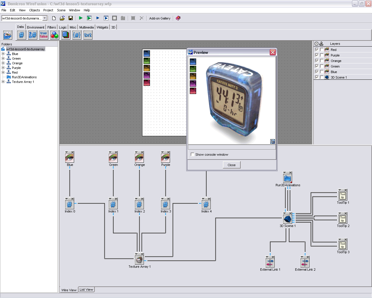 | WireFusion 3D is an add-on for WireFusion. With this add-on you can create real time interactive 3D presentations for the web. No plugin is required to view the presentations and the 3D engine, written in pure Java 1.1 code, is only 25 kb... |
|
Results in Tags For 3d map view
 | Earth Explorer 6.0 is GPS Enabled digital map software with high-resolution satellite images and SRTM imagery of the world. It is a kind of educational scientific software of geography... |
|
| Earth Explorer DEM integrates high-resolution shaded relief topographic imagery (built from 1km resolution digital elevation model) with kinds of map layers such as political boundaries, coastlines, rivers, lake and island boundaries, 267 countries and regions, 40000+ ranked cities, 15000+ islands, and 1700+ noteworthy historical earthquakes since 1980 into a fantastic 3D earth globe. You can specify what kinds of map layers to be shown, rotate the globe, click right mouse button and pull/push to zoom in/out the current map view, measure distance between any two points on the map, etc.
Key features:
1. A 3D bird's-eye view of our beautiful earth;
2. Photo-realistic shaded relief topographic imagery at 1km resolution covered entire earth globe;
3. Integrates with several kinds of map layers:
Vector map layers:
1) Political boundaries (International boundaries and internal boundaries);
2) Coastlines, lakes, islands and rivers;
3) Longitude-latitude grids;
Point map layers:
1) 267 countries/regions and detailed information;
2) 40000+ ranked cities and information;
3) 15000+ Islands and information;
4) 1700+ noteworthy historical earthquakes since 1980 and detailed information;
4. Rotate/Zoom in/Zoom out functions lets you observe our beautiful planet at any point (Click right mouse button and pull/push to zoom in/out the current map);
5. Three kinds of operation modes (Drag, Center, Measure);
6. Measure distance between any two points on the globe;
7. Intelligent tips when your mouse moves upon a country/city/island/earthquake's mark or name label;
8. Sort country/city/island/earthquake table according to selected titles and interactive operate with the label and mark on the map;
9. Save favorite maps with BMP, JPEG formats;
With the newly redesigned interface and configuration utilities with the highest level of features and quality, Earth Explorer DEM 2.5 works well under the Windows 98/ME/NT/2000/XP systems...
|
|
| With 3D World Map you can view the earth in 3D,and get reference on 269 countries and entities,locate and compare 30000 cities in the world,compute distance between any two points on the earth,and more.
The earth model is real 3D,you can amplify the altitude above sea level to see how the earth looks like.also you can run the program as screensaver,with the amazing earth displayed on the screen.
There is an mp3 player for listening to music during you browse the world,it will pick a number of songs randomly from several directories or from all files according your settings every time the program starts.
Almost everything is costomizable in this program,you can change the color of the earth,the color of any button or any windows and the text,if the text is too small or big,just zoom in/out by left and right drag together... |
|
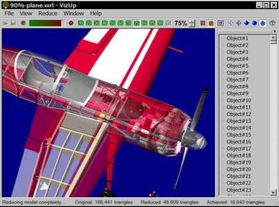 | VizUp Streamline is designed specially for game developers, architects, and 3D designers. With this software in place, they can reduce polygons and optimize 3D models. Supports Wavefront .OBJ, VRML 2.0/97 and StereoLitho (.STL) file formats...
|
|
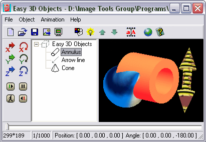 | Easy 3D Objects is intended for creation of 3D GIF- animations, banners, illustrations for the Web and presentation materials. You can use different types of objects,assign animation paths to objects, fill objects by color or texture and more..... |
|
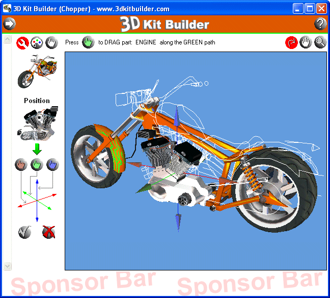 | Fun for all ages! Build and paint this "ready to assemble" high detail 3D Model Kit and learn why 3D is so creative and exciting!..
|
|
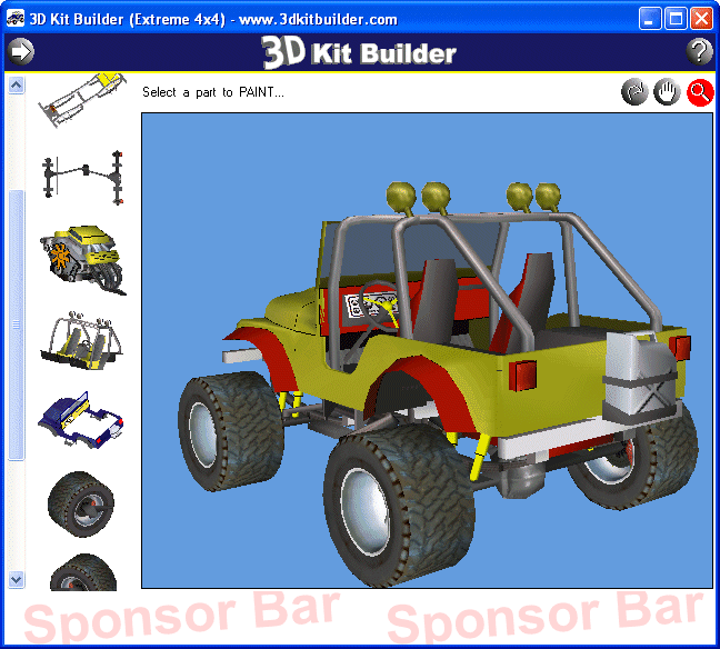 | Fun and Easy for all ages! Build and paint this "ready to assemble" high detail 3D Model Kit and learn why 3D is so creative and exciting!.. |
|
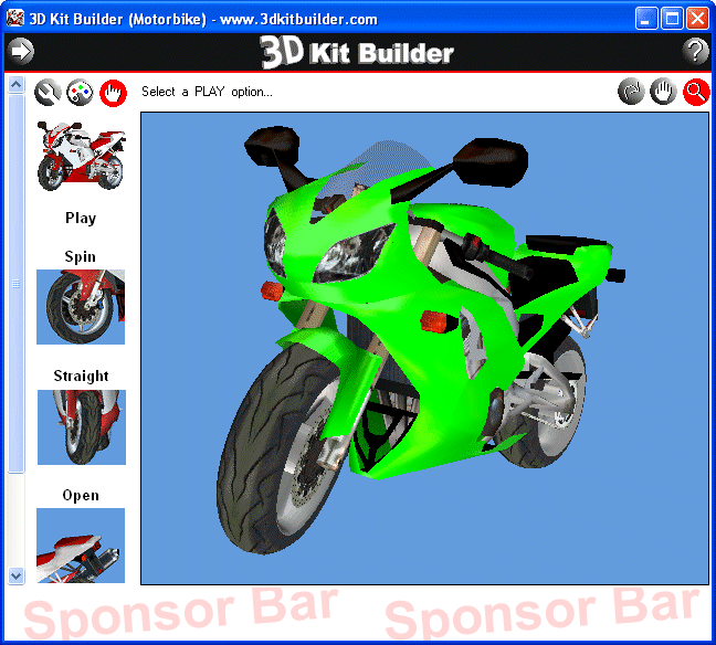 | Fun and Easy for all ages! Build and paint this "ready to assemble" high detail 3D Model Kit and learn why 3D is so creative and exciting!.. |
|
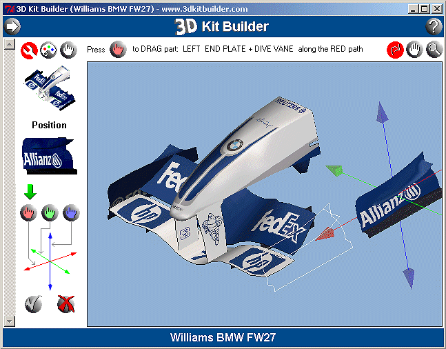 | Fun and Easy for all ages! Build and paint this "ready to assemble" high detail 3D Model Kit and learn why 3D is so creative and exciting!.. |
|
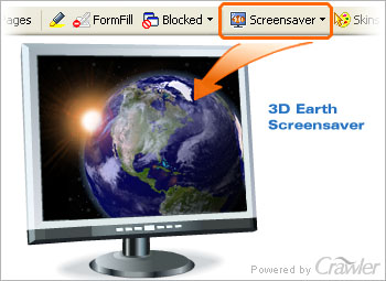 | Take a journey around the planet Earth! Download FREE 3D Earth screensaver and watch animated storms and hurricanes. Receive weather forecasts, explore foreign countries, zoom and rotate the globe. Watch planet Earth the way only astronauts do!.. |
|
Related search : ap layersexplorer demearth explorerislands and,click right mouseearthquakes since 1980measure distance betweencountry city islandcity island earthquakehistorical earthquakes sincenoteworthy historical earthquakesshaded relief topographicrelief topogrOrder by Related
- New Release
- Rate
view 3d files -
3d model view -
view 3d image -
2d svg to 3d view -
3d map -
|
|