|
|
ACT.Booster - Dresden Shopping App - Zombie High Series - Ristorante Peppino - Proverb Robo - Cars Memory Game - Richie Sambora Ringtones -
 | You can think of the Tometa WhereIs service as the Internet's telephone directory. It gives you information on the geographical location of an IP address based on Internet infrastructure information With a free SDK, email support and code examples in almost any language WhereIs easily provides infor...
|
 | GeoDataSource Cities Database Gold Edition contains 2.9+ million entries with city names in original language and English, feature type classifications, country names in FIPS and ISO, regions, sub-regions, state or First-Order Administrative Division, county or Second-Order Administrative Division, ...
|
 | GeoDataSource Free Cities Edition provides geographical database of world features, cities with place names and region names. Free database of worldwide cities in text format suitable for any applications requiring a comprehensive list of cities and country code. It is a subset of the paid edition o...
|
 | GeoDataSource Cities Database Premium Edition contains 2.9+ million entries with city names in original language and English, feature type classifications, country names in FIPS and ISO, regions, sub-regions, state or First-Order Administrative Division and county or Second-Order Administrative Divi...
|
RoboGEO (in Image Conversion)
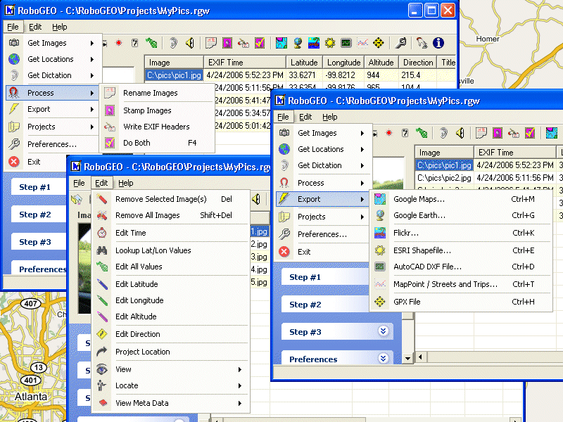 | Geotag digital images with latitude, longitude, altitude, and direction information. RoboGEO stamps this information onto the actual photo or writes it to the EXIF headers, allowing you to permanently geotag and link your photos to the GPS coordinates. All writing to the EXIF and IPTC headers is los...
|
 | GeoDataSource Structural Features Database Premium Edition contains structural feature names in original language and English, feature type classifications, country names in FIPS and ISO, regions and sub-regions. Database in text format suitable for applications requiring a complete list of city nam...
Tags: man-made structural database, latitude longitude, city latitude, cities database, world cities, global cities, world countries, distance calculator, state list, gazetteer, place names, populated places, gps, |
 | GeoDataSource Structural Features Database Gold Edition contains structural feature names in original language and English, feature type classifications, country names in FIPS and ISO, regions and sub-regions. Database in text format suitable for applications requiring a complete list of city names....
|
 | GeoDataSource Structural Features Database Basic Edition contains structural feature names in original language and English, feature type classifications, country names in FIPS and ISO, regions and sub-regions. Database in text format suitable for applications requiring a complete list of city names...
|
 | GeoDataSource Water Features Database Gold Edition contains water feature names in original language and English, feature type classifications, country names in FIPS and ISO, regions and sub-regions. Database in text format suitable for applications requiring a complete list of city names. It is a s...
Tags: water features database, latitude longitude, city latitude, cities database, world cities, global cities, world countries, distance calculator, state list, gazetteer, place names, populated places, gps, |
 | GeoDataSource Water Features Database Basic Edition contains water feature names in original language and English, feature type classifications, country names in FIPS and ISO, regions and sub-regions. Database in text format suitable for applications requiring a complete list of city names. It is a ...
|
 | GeoDataSource Water Features Database Premium Edition contains water feature names in original language and English, feature type classifications, country names in FIPS and ISO, regions and sub-regions. Database in text format suitable for applications requiring a complete list of city names. It is ...
|
 | GeoDataSource Land Features Database Premium Edition contains land feature names in original language and English, feature type classifications, country names in FIPS and ISO, regions and sub-regions. Database in text format suitable for applications requiring a complete list of city names. It is a ...
Tags: land features database, latitude longitude, city latitude, cities database, world cities, global cities, world countries, distance calculator, state list, gazetteer, place names, populated places, gps, |
 | GeoDataSource Land Features Database Gold Edition contains land feature names in original language and English, feature type classifications, country names in FIPS and ISO, regions and sub-regions. Database in text format suitable for applications requiring a complete list of city names. It is a sub...
|
 | GeoDataSource Land Features Database Basic Edition contains land feature names in original language and English, feature type classifications, country names in FIPS and ISO, regions and sub-regions. Database in text format suitable for applications requiring a complete list of city names. It is a su...
|
|
|